Colorado weather alert: 6-11 inches of snow possible Tuesday into Wednesday (2024)

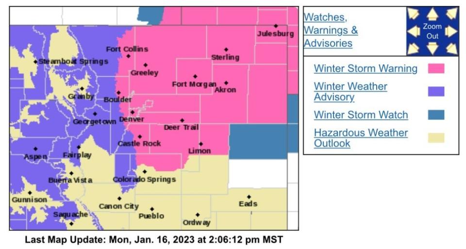
Fort Collins and the entire northeast quarter of the state is under a winter weather warning with impressive snow totals and strong wind expected to blast the area Tuesday into Wednesday.

Here's what we know as the storm approaches Colorado, according to the National Weather Service:

Winter storm warning includes eastern one-third of Larimer County; what does it mean?

The National Weather Service has issued a winter storm warning from 5 p.m. Tuesday through 5 p.m. Wednesday evening from the Colorado/Wyoming border line south to Castle Rock and east to the Nebraska/Kansas borders. The area could see 6 to 11 inches of snow with up to 35 mph wind gusts.

A warning means there is a strong likelihood for significant and hazardous winter weather.

Timing of storm and travel impacts

Tuesday afternoon: Snow develops in the mountains and spreads onto the Eastern Plains.

Tuesday night: Snow intensifies, with locally heavy bands developing on the Eastern Plains.

Wednesday: Snow continues, gradually ending west to east through the day.

If heavier snow develops earlier on Tuesday, the evening commute could be impacted. Wednesday morning's commute is expected to be impacted.

Interstate 76 runs directly through the higher forecast snowfall area and is expected to see difficult travel conditions. The same is possible for U.S. Highway 34 from Greeley east to the Nebraska state line. The eastern section of Colorado Highway 14, Interstate 70 and Interstate 80 through southern Wyoming from Cheyenne east are also expected to see impacts.

Interstate 25 could see some impact from Fort Collins south to Castle Rock.

Fort Collins breakdown of when snow arrives, falls heaviest

11 a.m. to 5 p.m. Tuesday: 30% chance of snow. Less than a half-inch expected. Wind 5-10 mph, gusting to 16 mph

5 p.m. Tuesday to 5 a.m. Wednesday: 80% chance of snow. 3-5 inches of snow expected. Wind 7-9 mph, gusting to 15 mph

5-11 a.m. Wednesday: 60% chance of snow. Wind 11-14 mph, gusting to 22 mph

11 a.m. to 4 p.m. Wednesday: 30% chance of snow

A look at probable snowfall totals; Eastern Plains wears the bullseye

Here are the probabilistic snowfall forecast totals predicted by NWS as of Monday:

Fort Collins: 6 inches expected: 98% chance 1 inch or more, 89% chance 2 inches or more, 61% chance 4 inches or more, 40% chance 6 inches or more and 19% chance 8 inches or more

Greeley: 7 inches expected: 95% chance 2 inches or more, 71% chance 4 inches or more, 49% chance 6 inches or more and 26% chance 8 inches or more

DIA: 8 inches expected. 99% chance 2 inches or more, 80% chance 4 inches or more, 61% chance 6 inches or more and 40% chance 8 inches or more

Downtown Denver: 7 inches expected. 97% chance 2 inches or more, 76% chance 4 inches or more, 57% chance 6 inches or more and 37% chance 8 inches or more

Boulder: 5 inches expected. 98% chance 1 inch or more, 83% chance 2 inches or more, 54% chance 4 inches or more, 32% chance 6 inches or more and 4% chance 8 inches or more

Sterling: 8 inches expected. 97% chance 2 inches or more, 79% chance 4 inches or more, 62% chance 6 inches or more, 44% chance 8 inches or more and 5% chance 12 inches or more

Fort Morgan: 8 inches expected. 97% chance 2 inches or more, 77% chance 4 inches or more, 59% chance 6 inches or more, 39% chance 8 inches or more and 5% chance 12 inches or more

Holyoke: 10 inches expected. 92% chance 4 inches or more, 74% chance 6 inches or more, 60% chance 8 inches or more and 26% chance 12 inches or more

Castle Rock: 7 inches expected. 96% chance 2 inches or more, 76% chance 4 inches or more, 58% chance 6 inches or more and 29% chance 8 inches or more

Winter Park: 8 inches expected. 84% chance 4 inches or more, 52% chance 6 inches or more and 15% chance 8 inches or more

Walden: 2 inches expected. 78% chance 1 inch or more, 53% chance 2 inches or more and 2% chance 6 inches or more

Breckenridge: 4 inches expected. 90% chance 2 inches or more, 46% chance 4 inches or more and 3% chance 6 inches or more

Vail Pass: 8 inches expected. 92% chance 4 inches or more, 61% chance 6 inches or more and 30% chance 8 inches or more

Durango: 8 inches expected. 85% chance 6 inches or more, 66% chance 8 inches or more and 28% chance 12 inches or more

This article originally appeared on Fort Collins Coloradoan: Fort Collins could see significant snow. How much can we expect?
Colorado weather alert: 6-11 inches of snow possible Tuesday into Wednesday (2024)

FAQs

How much snow is expected near Denver CO? ›

0" over next 8 days.

How many inches is Boulder expecting? ›

0" over next 7 days.

How much snow did Fort Collins get in the last 24 hours? ›

52%
Geolocation40.58, -105.09
Past 24hrsNone inches
24hr Forecast0 inches
120hr Forecast0 inches
Peak Snowpack22 inches
5 more rows

When can I see snow in Colorado? ›

Winter: Mid-November to Early-April

Colorado is a true winter wonderland with plenty to see and do. While snow is probable most of the season, the heaviest snows are January to March and even April can experience heavy snow. Despite all of the cold, there are still special winter days well into the 70s.

Where in Colorado will get the most snow? ›

The snowiest city in Colorado is Crested Butte with an average snowfall of 216.6 inches, though this is debateble. The least snowy city in Colorado is Grand Junction with an average snowfall of 15.8 inches. March is typically the snowiest month in Colorado.

Is snowfall decreasing in Colorado? ›

We do know average high elevation snowpack has decreased over time in Colorado, but 3”+ snowstorms on the Front Range have not.

How big is a rock before it becomes a Boulder? ›

In geology, a boulder (or rarely bowlder) is a rock fragment with size greater than 25.6 cm (10.1 in) in diameter. Smaller pieces are called cobbles and pebbles. While a boulder may be small enough to move or roll manually, others are extremely massive. In common usage, a boulder is too large for a person to move.

How long has the sink been in Boulder? ›

It was amazing to finally get to go in after hours and see the remnants of a life that was so mysterious to me. The Sink opened in 1923 as Somer's Sunken Gardens, in the former Sigma Nu fraternity house.

How high is the Boulder problem? ›

Boulder problems are generally shorter than 20 feet (6.1 m) from ground to top. This makes the sport significantly safer than free solo climbing, which is also performed without ropes, but with no upper limit on the height of the climb.

Who gets more snow Colorado Springs or Fort Collins? ›

Climate Averages:

Colorado Springs has 2.5% or 6 more Sunny Days than Fort Collins. Colorado Springs gets more snow 57.1 inches vs 48.1 inches for Fort Collins every twelve months.

Where did it snow 100 inches? ›

Soda Springs picked up 116 inches. Kingvale reported 106 inches, and the Palisades Resort in Tahoe got 93 inches. The U.C. Berkeley Central Sierra Snow Lab picked up 75.2 inches from this storm, and endured hours without power due to the combination of heavy snow and high winds bringing trees and power lines down.

Has a tornado ever hit Fort Collins? ›

Seven tornadoes have struck Fort Collins since 1954, according to the Tornado History Project. Each one has ranked as one or lower on the Enhanced Fujita scale, which goes from zero to five. An EF0 tornado means wind speeds of 65 to 85 mph with minor or no damage.

Has it ever snowed in June in Colorado? ›

The absolute latest date that Denver has received measurable snow is June 2, 1951. According to the NWS, on that date, Denver got 0.3 inches of snow. That is the only recorded date in June with any measurable snowfall in the city.

Has it ever snowed in May in Colorado? ›

It's often feast or famine - some years, you get a giant storm in May, other years, it's a couple of inches of snow and that's it. On average, Woodland Park gets between 6 and 8 inches of snow in May...but again, that really depends on the year.

What is the snowiest day in Colorado? ›

The U.S. state that had the largest recorded snowfall was Colorado, where 63 inches of snow fell more than a century ago on Dec. 4, 1913, at the Georgetown weather station. That's nearly twice the average snowfall in Colorado for the entire winter season!

Is there snow on the ground in Denver right now? ›

There are currently no active snow events at this location.

How much snow does Denver usually get? ›

Throughout the snow season, Denver usually gets 56.9 inches of snow based on measurements taken at Central Park, and areas near the Denver International Airport see around 47 inches.

Does it snow more in Denver or Colorado Springs? ›

Denver: Sitting at 5,280-5,313 feet, Denver tends to get more snow, averaging 57.3 inches per year, and experiences warmer, drier summers with several days reaching above 100º. Both cities have mild weather year-round, but Colorado Springs generally offers more comfortable summer conditions.

How many inches of snow does Colorado get in a year? ›

Snow in Colorado

Colorado's annual average snowfall total is 219". The table below shows the snow cover in Colorado. Note that snowpack levels across Colorado aren't reported during the off-season period.

References

Top Articles
Latest Posts
Article information

Author: Roderick King

Last Updated:

Views: 6357

Rating: 4 / 5 (51 voted)

Reviews: 82% of readers found this page helpful

Author information

Name: Roderick King

Birthday: 1997-10-09

Address: 3782 Madge Knoll, East Dudley, MA 63913

Phone: +2521695290067

Job: Customer Sales Coordinator

Hobby: Gunsmithing, Embroidery, Parkour, Kitesurfing, Rock climbing, Sand art, Beekeeping

Introduction: My name is Roderick King, I am a cute, splendid, excited, perfect, gentle, funny, vivacious person who loves writing and wants to share my knowledge and understanding with you.